Best Sailing Routes in Croatia
Croatia’s shoreline has dozens of stunning islands that range in size from tiny, lush, uninhabited islands to large, desert outcroppings with historical cities and villages. Despite being one of Europe’s most well-known tourist destinations and the world’s leading sailing destination, Croatia does not appear to have been overrun by the tourism industry. The country has a plethora of natural resources, including about 2000 kilometers of rocky, indented coastline and over a thousand islands, many of which are covered in lush flora. So, in this article, I’m going to list the best sailing routes in Croatia in order for you to choose the best sailing itinerary!
Sailing Information about Croatia
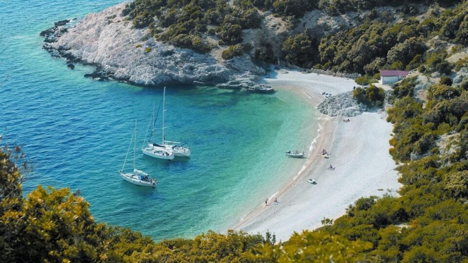
The Adriatic Sea, one of the most tranquil and transparent in the Mediterranean, is the ideal location for sailing. Croatia’s coastline, stretching for 6278 kilometers, with 1244 islands, islets, rocks, and reefs, as well as hundreds of wet and dry berths available year-round, and contemporary marinas. Sail from island to island in the Kornati archipelago, anchor in coves or natural shelters, go underwater fishing in Pakleni Otoci, see the famed Palagruza lighthouse, Croatia’s most remote island, and dock at the incredible Elaphiti Islands.
From Dubrovnik’s picturesque hamlet of Cavtat and the enigmatic Lokrum Island, through Vela Luka on Korula, Hvar and Vis, and all the way to Losinj and Istria, explore an endless blue of possibilities. Discover hidden bays and beaches, book a berth at a port or marina and explore the Mediterranean lifestyle, or sleep comfortably beneath the stars!
Croatia’s interior will charm you with olive groves and vineyards, Mediterranean herbs, lavender, cypress, and pine trees. It’s important to note that Croatia is one of the few countries with a developed forestry ecosystem that occupies 37 percent of the country’s total land area and is home to a plethora of unique natural phenomena, including eight National Parks and ten Parks of Nature.
Croatia’s Regions
The country is divided into 5 main regions: Eastern Croatia – Slavonia (Osijek, Pozega), Central Croatia (Zagreb), Highland Croatia (Gospic), Southern Littoral – Dalmatia (Dubrovnik, Split, Zadar), and Northern Littoral – Istria (Pula, Rijeka). The current regional divisions are based on the country’s relief division.
Eastern and Central Croatia split the country’s northern, primarily lowland region. The traditional areas of Slavonia, Baranja, and the western part of Srijem, i.e. the actual lowland area of the Pannonian Plain, are bounded by the three largest rivers, the Sava, Drava, and the Danube. The ideal circumstances for agricultural development are in this location. Osijek, a port on the Drava, is the regional capital. Vinkovci, a transportation center, Vukovar, the country’s main river port, and the only Danube port. Also, other large towns include Slavonski Brod, Pozega, and Dakovo.
The Pannonian Plain’s border territories, as well as the peri-Pannonian regions of Hrvatsko Zagorje, Medimurje, Pokuplje, and Banovina, make up Central Croatia. With Zagreb as the country’s capital, it is the country’s population and economic center. Varazdin, Cakovec, and Krapina are large towns and regional centers in the north. Karlovac and Sisak in the south, and Bjelovar and Koprivnica in the east.
Highland Croatia is the smallest and least inhabited region of the country, and it encompasses a steep terrain. It is made up of smaller units, including Gorski Kotar, the Ogulin–Plaski depression, and Lika, which are all forest areas. There is minimal arable land due to the relief and temperature, thus only cultures that can tolerate harsh winter conditions grow there. The economy’s most important branch is forestry, which is dependent on local resources. Delnice, Ogulin, and Gospic are the regional centers, and towns are smaller than in other parts of the country.
The country’s coastal region is traditionally separated into two parts: north and south. The Hrvatsko Primorje (Croatian littoral) area includes Istria, Croatia’s most developed tourist region, as well as the long, narrow Kvarner region underneath Velebit and the neighboring islands. Rijeka, the largest Croatian port, is the major city and regional center. Pula and Porec in Istria and Senj in the coastal belt below Velebit are other major cities. Rovinj and Opatija, as well as the islands of Krk, Rab, and Mali Losinj, are popular tourist destinations.
Dalmatia’s historical region is primarily made up of the southern littoral. It is a distinctively Mediterranean region in terms of climate, environment, and culture, with three parallel belts: the islands, the coast, and the hinterland. Split, Croatia’s second-largest city and the largest on the coast, serves as the regional hub. The coastal cities of Zadar, Sibenik, and Dubrovnik, as well as the inland towns of Knin and Sinj, are key regional and economic centers.
Weather in Croatia
If your dates are flexible, a sailing trip in June or September is a good choice. Prices are lower, and the streets are less congested and crowded. The best time to rent a boat or take your boat to Croatia is in April, May, and October. Variable weather is more likely in autumn when weather systems are moving rapidly over Europe. However, the weather is frequently mild and pleasant until November. Including the sea, which has a constant temperature of roughly 20 degrees (68F). Spring in Croatia is beautiful, with mild weather and comfortable air temperatures. Despite the low sea temperatures, which reach 20°F (68°F) starting in mid-May, sailing is a genuine joy until mid-June.
High summer, which begins in the latter weeks of June, is busy, but the weather is near-perfect, with fair winds and air temperatures regularly above 30 degrees (86F). If you enjoy the heat of summer, plan your sailing holiday for July or August. Keep in mind that the most expensive months to charter a yacht are July and August, although you can usually get a good offer. Most of the popular marinas are full in August, with Italians crossing across and staying until the evening. So it’s best to be safe and catch your mooring early in the afternoon with an early bird.
The beauty of the Croatian coast, as well as the variety of sailing conditions, contribute to the popularity of the Croatian coast as a sailing destination. The sunny Adriatic has 315 cloudless days each year on average. Blue skies and warm weather prevail during the most popular chartering season, which runs from May to November. Summers are hot and dry, but winters are pleasant with brief rain showers, like in the Balearic Islands or Corsica. However, you must check the weather regularly because it can change rapidly.
The major winds in Croatia are:
- The Bura: This is a brisk, dry breeze. Because it is north-easterly, it primarily blows from land to sea along the Adriatic coast. The Bura brings pleasant weather. It blows locally with different ferocity and from numerous directions ranging from N to ENE due to the land’s shape. Because of the relief to the east of the Adriatic, the local Bura winds blow in strong gusts and start abruptly. The Bura’s strength can range from a gentle breeze to a strong gale.
- The Maestral: Day by day, the land surface heats up faster than the sea surface, causing air currents to rise from the land and drag down to the sea after a given distance, generating land-sea circulation. White cumulus clouds, which indicate good weather, are typical of the Maestral. It normally starts blowing between 9 and 10 a.m. and reaches its peak force at about 2 p.m. Before dusk, it always fades away. It has a typical force of 16-20 knots.
- The Sirocco: From the ESE to the SSE, a warm, humid wind blows. It blows along the entire Adriatic coast, causing rough seas. It causes thick clouds and prolonged rain. In the South Adriatic, it reaches its peak strength. It has the ability to blow at any time of the year. The Sirocco blows at 16-20 knots on average.
Now, I will list the best sailing routes for both Northern and Southern Littoral of Croatia. Bear in mind that the below-mentioned distances are approximate due to the fact that you will make more or less layovers. The best routes include:
- Pula – Zadar Archipelago – Šibenik (200NM)
- Pomer – Rijeka – Kvarner Gulf – Zadar (180NM)
- Split – Vis – Hvar – Dubrovnik (160NM)
Pula – Zadar Archipelago – Šibenik Sailing Routes
Pula – Brijuni National Park – Unije – Susak (40NM)
Before setting sail from Pula’s marina, spend some time strolling around the ancient Mediterranean town of Pula. The Arch of Triumph, the ancient temple of Augustus, and the Roman amphitheater, which has become the city’s landmark, are among the top sights to see in Pula. Then, head to the surrounding Brijuni National Park, which is only five miles from ACI Pula. Depart from one of the city’s two main marinas, ACI Pula or Marina Veruda.
The 14 islands of Brijuni National Park make up the park. Spend the night on the largest island, Veli Brijun, which has a small marina. Many beachfront homes, Roman remains, and a Safari park are the main attractions on the islands. Cycling or strolling along the island’s paths are also great options. You can then set sail from Brijuni National Park to Susak Island, which is around 33 miles long. You’ll pass the southern tip of the Istrian peninsula and Premantura, where you may explore Cape Kamenjak Park, along the way.
The entire area surrounding the peninsula is famed for its hidden coves and isolated beaches with deep blue to dazzling emerald green sea. You may anchor in a nice sandy bay on Susak, but be careful when the Bura winds are high. Alternatively, you can sail to Unije, which is located further north and has more protected bays, some of which have moorings.
Premuda – Silba – Olib – Otok Škarda – Ist – Dugi Otok (60NM)
From Susak Island continue to Premuda. It is 18 NM from the Losinj archipelago from either Susak or Unije. If Premuda seems far for you, then you can sail to Ilovik, which is only 10 miles away from Susak. Mooring buoys or on the dock are available in the village of Ilovik.
Because the small port on Premuda may be full during the summer months, mooring buoys are near the front of the island. The unique chapel of San Ciriaco, as well as a modest pub where you can have dinner, are both located right at the port. Premuda has a rough topography, with the majority of the island’s vegetation consisting of stone pine trees and evergreen plants. Stroll around, enjoy the landscape, and the aroma of wild herbs that grow on the island. If you’re into scuba diving, you can head to “Katedrala”, a cave system that has a special light effect due to its porous ceiling.
From Premuda you have many choices. You can either head to the island of Olib or stop at the nearby island of Silba. Silba is located just 5NM from Premuda and Olib is at 8NM. In Silba, you can use the little marina of Mul or anchor in the popular Porat Sv. Ante in the southwest. The settlement is roughly a 40-minute walk from Porat Sv. Ante. If you’re returning from town in the evening, bring a flashlight because the trail takes you through the woods. Silba is popular for its beautiful sand, pebble, and rocky beaches, all of which are accessible via a small footpath. The sandy beach of Sotorisce on the southern part of the island and the pebble stone beach in the Bay of Pocukmarak are great places to enjoy your swim.
Olib is located on the east side of Silba and it’s a picturesque, flat island, with sandy beaches surrounding it. You can moor at Luka Olib harbor or drop anchor in the bay of Luka Sv. Nikola. The little island Otok Skarda, which is part of the Zadar archipelago, and is northwest of Ist and southeast of Premuda. On the north side, there is a little town with good anchoring. Depending on the winds, the ideal anchorage is located SE of the island at Uvala Griparica which is a destroyed castle near the bay’s bottom.
Ist is a small, peaceful island in the Zadar archipelago, located 21 nautical miles northwest of Zadar. Because of its unique shape, the island is known as a “Butterfly” island. Ist is an ideal place for those seeking peace, tranquility, and a slightly hidden vacation away from the throng and bustle of the city. The interior is hilly, with vineyards and olive orchards providing a breathtaking view. Then, from Ist set sail for Dugi Otok which is about 8NM away.
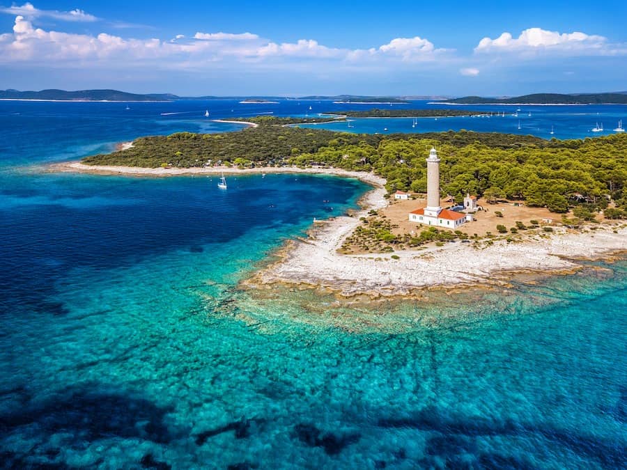
You can either anchor in the huge Bay of Sakarun or sail to Veli Rat, Dugi Otok’s northernmost settlement, which has a modest but modern marina. You’ll also find a small grocery, as well as a café and restaurant, in Baoti Marina. The Punta Bjanca lighthouse, three kilometers northwest of Veli Rat, is the village’s primary attraction. If you choose to anchor at Sakarun, you will be on one of Croatia’s most beautiful beaches. Dugi Otok has sheer cliffs along the shoreline, which are especially magnificent when viewed from a boat. The large vineyards and orchards will impress you, and consider visiting the Natural Park Telašćica on the southern end of the island.
Kornati Archipelago – Kaprije (51NM)
From Dugi Otok Island set sail for the nearby Kornati Islands. The Kornati islands are the Adriatic Coast’s northernmost archipelago consisting of 140 islands and islets. Within two weeks, there is more than enough to see and explore in the marine National Parks and spectacular landscapes. There are numerous choices there as scattered islets and islands are everywhere in the archipelago. The islands are separated into two groups geographically: Gornji Kornati (Upper Kornati) and Donji Kornati (Lower Kornati). Gornji Kornati is closer to the mainland and includes Zut Island, Sit Island, and the adjacent islets. Donji Kornati is more open to the SW and includes the island of Kornat, Piskera, and numerous more islands and islets.
The islands of Donji Kornati are part of the Kornati National Park. Sailing is allowed all around the Kornati National Park except in the zones of strict protection. These are around Purara islet, Klint and Volić reefs, Mrtenjak islet, Kolobučar islet, and Small Obručan and Great Obručan islets.
Don’t miss another treasure of the Adriatic Sea, Telašćica Nature Park, if you’re sailing through the Kornati. The park is located in the south-eastern section of Dugi Otok, north of Kornati. Moor or anchor your boat in Telašćica Bay. It’s one of the safest and most beautiful bays in the Adriatic, surrounded by numerous small islets and beaches. Then, climb up to enjoy a breathtaking view of 160 meter-high cliffs (stijene), or swim in the salt lake known as ‘Mir’ (peace), popular for its medicinal properties.
Continue sailing towards the Kornati strait, passing through the islands of Kameni Zakan and Ravni Zakan, which offer great swimming opportunities. You can stay overnight at the ACI marina Piskera marina, and recharge your batteries using shore power. You might also anchor in Lavsa if you like someplace a little more isolated. Stop at some of the local taverns on the Kornati islands, as the beauty, delicious cuisine, and friendly people will add to the wonderful sailing experience.
In order to continue to Kaprije you will pass the big island of Kurba Vela. But, watch out for the rock when leaving it behind which is about 200m NW of the island of Mali Garmenjak. It’s worth noting that the Kornati archipelago has many small rocks in the sea or hazardous shallows. So, always advise the Kornati islands Nautical Charts. Kaprije, like the Adriatic’s modest flower bud, will enrich your sailing experience, especially if you’re looking for solitude and quiet. And, it’s true that these are becoming increasingly difficult to come by but you will find them there.
Because there are no cars on this small island, the only time of commotion is during the summer months. The best shelter is in Kaprije harbor, which is located in the northwestern section of the island. This steeply concave bay, also known as St. Peter’s Harbour, provides excellent protection from all winds except the mistral and tramontane, and it’s not suitable for mooring during summer storms. Buoys are anchored in all of the desolate coves. Boaters frequently visit the restaurants of Medo and Mala Nozdra which are only accessible by boat. Due to the fact that the aforementioned coves are not protected from south winds, the safest option during Sirocco is to seek shelter at Vanjska Cove, which has mooring sites.
Zlarin – Šibenik (15NM)
Zlarin Island is located off the Croatian mainland coast, a little under three miles southwest of the port of Sibenik. It is the largest of a collection of islands that stretches from the canal leading into Luka Sibenik. This is the inland sea off the port of Sibenik, to the Kornati archipelago. The only village on the island lies on the Luka Zlarin Bay which has a harbor and a sandy beach. You can berth at the outer side of the pier. But, the harbor is exposed to northwesterly winds so it’s not advisable to moor during bad weather.
From Zlarin sail for 3NM to your last (or not), layover, Sibenik. Šibenik has everything for a complete sailing Adriatic voyage. Tranquil streets, historical city walls, and a clear sea. Its port is blissfully uncrowded in comparison to Zadar, and the city has better connections with the variety of islands and islets that define this region. A short sail away is the bizarre Kornati archipelago, a scattering of bone-dry islands surrounded by translucent waters. Sailing in Sibenik is the perfect alternative to the normal circuit. You can combine visiting a Medieval city with easy access to unspoiled wilderness, without the flashy glitz of Hvar. Sibenik is proving to be just as attractive as its neighboring coastal resorts. It has an abundance of infrastructure and accessible marinas that particularly please sailing aficionados.
>>Also Read: Best Marinas in Europe
Pomer – Rijeka – Kvarner Gulf – Zadar Sailing Routes
Medulin – Rabac – Mošćenička Draga – Rijeka (39NM)
Pomer is roughly an 8-kilometer drive south of Pula. In fact, it’s a lovely Mediterranean setting that hasn’t lost its charm. It’s possible that you will think like you’re traveling back to the nineteenth century. Pomer, which is located on the west coast of Medulin, is notable for its shallow coastline region. Its small harbor also gives protection from high winds. Pomer and its environs are still in good condition, which contributes to their beauty. A must-see for anyone who enjoys sandy beaches is Medulin. Bijeca beach is a well-known beach in Medulin. This shoreline has elevated the region’s profile. The port has grown significantly in order to provide a vibrant environment for everyone. In addition, the bay contains three islets; Ceja, Brodulas, and Levan. The latter is a small sandy islet in the middle of the ocean.
Rabac is an ideal resort town and a great place to start exploring the Adriatic Sea. In addition, the bay has beautiful pebble-stoned beaches, four of which have been awarded the “Blue Flag” designation. The untamed and unspoiled flora of the Istrian region is typical there.
From Rabac continue to Moscenicka Draga for about 10NM. A small fishing village, with a charming pebbly beach, ideal for tranquility and relaxing aboard. Moscenicka Draga is a charming destination due to its pleasant climate, beautiful pebbly beaches, and convenient access to Opatija, Lovran, and Rijeka. The small settlement of Moscenicka, located on a nearby hill, gives the most stunning view of Kvarner bay. After spending some relaxing days aboard, continue to the lovely town of Rijeka. If you have enough time, spend some days wandering around the port city of Rijeka. It’s really worth swimming in its Blue Flag crystal clear beaches. It also has a historic town with plenty of Neoclassical architecture buildings. Risnjak National Park, a thickly forested, hilly location with several paths for outdoor enthusiasts, is also well worth seeing.
Krk – Cres – Losinj (55NM)
From Rijeka sail to the popular Krk Island. Krk Island is located in Croatia’s Rijeka Bay, sandwiched between the mainland to the east and the long island of Cres to the west, separated by a three-mile strait. The island’s north and northwest coasts are largely steep and rocky, with few settlements; however, the island’s south and southwest coasts have a warmer climate, with more forests and farmland. It also has the principal settlements of Krk Town, Punat, and Baska. The island’s principal harbor, Krk Town, has moorings for boats and provides adequate cover in all but the strongest southerlies. There’s also the inlet of Punat, two miles east, which features Marina Punat. This is an 800-berth marina that is highly popular with over-wintering boats.
From Krk continue sailing to the nearby Cres Island. The island is located in the Kvarner Gulf, off the coast of Croatia’s wide peninsula of Istra. It is exactly between the islands of Krk and Rab. In terms of land size, it is not the largest of the Croatian islands, but it is the longest. Its climatic range and vegetation range from the Mediterranean at the southern end to virtually sub-alpine at the northern end.
Apart from the minor harbors of Valun, Martinscica, and Osor on the SW coast, the island’s major harbor, Cres Town, has a 473 berth marina, but the rest of the island, particularly at its SE extremity, has only anchorages. The view on the island will take your breath away once you’ve gotten off the mainland. Cres’ shoreline is lined with several bays and coves beckoning you to explore them. The ancient forests and secret communities that dot the hilltops harken back to a simpler and, in some ways, more mysterious era. The cliffs are massive and daunting, rising straight up from the sea and even upward in some places.
Continue sailing to the neighboring island of Losinj, the island of vitality, which is about 19NM away. Keep in mind that you should set sail from around Mali Bok, or Punta Kriza (Cres) in order to continue on the correct route. Of course, you can set sail from the west side of Cres to get to Losinj but you will need more time and thus sailing in order to get to Rab and Pag Islands.
For your stay in Losinj, you have the option of anchoring in the huge, safe harbor of Artatore. Or, you can stay in one of three marinas in Veli Losinj. In the village of Artatore, you may dine in one of three excellent restaurants that serve fresh local cuisine. The people there are very hospitable and the village located in the heart of a pine forest. You could also pay a visit to Mali Losinj, a more well-known village. There you can take in the bustling ambiance of the restaurants and bars that line the harbor. The view of the island can also be enjoyed from the Church of St. Nicholas in the town center.
Rab and Pag Islands (30 NM)
Next stop from Losinj, the islands of Rab and Pag, with a total distance of 50 NM including several layovers. Rab has about 2500 hours of sunshine, making it one of Europe’s sunniest spots. Despite this, the island receives enough rain to maintain it lush and verdant. The heavily indented shore, particularly in the southwest, is dotted with pine-rimmed coves. Lopar, in the northeast, has two of Croatia’s best beaches. Vineyards, olive groves, and vegetable gardens dot the countryside. The numerous little islets, as well as the favorable winds, are the reason why the waters around the island attract sailors in the summer. On the island, there are two marinas that provide all a sailor needs in terms of infrastructure and comfort.
Pag Island is 19NM if you set sail from ACI Marina in Rab and head to Simuni Marina in Pag. However, there are other great anchorages at the villages of Zubovici and Caska in the inlet of Pag Town. Also, from south to north others include Kosljun, Povljana, Novalja, Jakisnica, and Tovarnele on the west coast.
Pag Island is a long and narrow island off the coast of Croatia, opposite the Velebit mountain range, and is the country’s fifth-largest. Rab, Olib, and Vir are some of the nearby islands. The Velebit Channel, on its eastern side, is noted for the ferocity of its winds during a powerful bora. Unlike some of its neighbors, the island is largely devoid of trees, and its economy is based mostly on fishing, tourism, and the manufacture of wine and cheese. The acidic, salty Pag cheese, which is steeped in olive oil, is widely regarded as one of Croatia’s best cheese.
Otok Maun – Vir – Zadar (25NM)
Continue sailing for about 3NM from Pag to the island of Maun. The little Maun island is located in front of the island of Pag’s south-western coast. It is separated from the island by the Maun Channel, which is five kilometers wide. Otok Maun is a narrow island with few plants and grass covering it. Moreover, several islets are located on a shoal bank that stretches up to 1.8 miles ESE of the island’s southern extremity. For example, Otok Skrda is a 65m high rocky and naked island located 1 mile NW of Otok Maun’s NW extremity. It is also fronted by a reef on its SE end.
Rakovica Bay on Maun Island is a wonderful area to stay the night, especially since there aren’t many safe coves along Pag’s southern coast apart from ACI marina Simuni. You are welcome to stay the night at Rakovica as long as the forecast does not include Bora. This is the northeast wind that would cause the bay to close. Jagged areas form sharp rocks that divide the bay into two smaller bays. Keep in mind that the depth and the seafloor are two of the bay’s best features. The anchor can hold well in the middle of the southern part of the bay, where the depth is between 7 and 10 meters.
Continue for about 7 NM to the island of Vir. Vir really offers the best of both worlds, as it is both an island and a bridge connecting it to the mainland. Its nice climate and picturesque surroundings in a tiny Mediterranean town make it a popular vacation spot. There are just three villages on the island of Vir: Vir, Lozice, and Torovi. All of these are along the seashore, which is full of coves and beaches. The most beautiful beach, however, is thought to be in the Duboka draga (“deep cove”) in the northwest of the island. The combination of pristine nature and crystal-clear waterways, as well as unusual red rocks, creates an outstanding natural spectacle.
And, then your last (or not) destination the wonderful city of Zadar (12NM). In the heart of the Adriatic, Zadar is an old Mediterranean city with a rich history and remarkable cultural legacy. Plitvice Lakes, Paklenica, Krka waterfalls, and Kornati National Parks surround it, making it the urban heart of northern Dalmatia. Zadar region is a great spot to start sailing if you want to get away from the more touristy regions of Dalmatia. On the other hand, Zadar is also a centrally positioned town, and a great site to end your sailing voyage or just stay for a while. Many sailors are drawn to this location by its unspoiled landscape, indented shoreline packed with hidden bays, beaches, and wonderful weather.
>>Also Read: Best Sailing Destinations in Europe
Split – Vis – Hvar – Dubrovnik Sailing Routes
Split – Solta – Brac (25NM)
A well-known tourist attraction and sailing departure point – Split – with a plethora of things to see and do. The Diocletian Palace, one of the masterpieces of the old Roman Empire, is the most popular attraction in the city. The Cathedral and Tower of St. Dominus, Procurativa and Republica Squares, Jupiter’s Temple, Peristyle Square, and the numerous waterfront cafés and restaurants on the Riva are also historical landmarks. You can set sail for Solta Island from the ACI Split marina.
Despite its proximity to Split, the island of Solta is not so frequented by visitors. As a result, it remains one of the most pristine on the Croatian coast and is a great place for peace and solitude. Solta is a wonderful site to sample locally produced olives and honey, as well as wine from the island’s vineyards. The heart of the western half has a fertile plain. There are numerous bays and coves with natural beaches along the shore where you can also anchor. Rogac and Necujam are the major bays on the northern shore, which are exposed to northerly winds. A collection of islets and reefs protect Maslinica Bay on the western coast, which is only exposed to northwesterly winds.
Continue sailing for about 8NM for Brac Island. It’s the largest island in the Central Dalmatian island group and also the third largest on the Adriatic. Its landscape is marked by karst features including cracks, caves, and hollows. There are no surface streams, and the few permanent springs are found in the vicinity of Bol. The gorgeous beach of Zlatni Rat near Bol is known around the world as one of the centerpieces of Croatia’s tourist attraction. Vidova Gora, the island’s highest point, is also the highest peak in Croatia, standing at 778 meters. Furthermore, there are many berthing and anchoring options. The best ones include Smirka, Blaca, and Velika Studena, especially if you continue sailing to Hvar Island.
Hvar – Vis – Korcula (65NM)
Hvar is basically the longest island in the Adriatic Sea. The western half of the island is the widest and most rugged. Sveti Nikola (628 m) is the island’s highest peak, rising above the southern shoreline. The entire coast is rocky and dotted with bays. The forest almost always reaches all the way to the seashore on the island. The northern coast is significantly more craggy than the southern coast. The island’s rocky spine rises to 628 meters at its highest point south of Stari Grad.
It’s worth noting that much of its coastline, particularly on the south and west sides, is full of several small bays that provide anchorages suited for a variety of wind conditions. Aside from the normal crops of grapes, figs, and olive oil, Hvar is popular for its lavender production. You will be able to scent the aroma from several kilometers offshore at certain seasons of the year.
Continue sailing for about 16NM from Hvar to the Island of Vis. Vis is a popular summer port of entry for yachts arriving in Croatia from Italy. Because of its remote location from the mainland, the island is less impacted by tourists than some of the other islands. That’s why it has remained largely unspoiled. Today, Vis is known for its wines, and the island’s central region is covered in vineyards. Sailboats primarily use the ports of Vis on the north coast and Komia on the west coast, though there are other decent anchorages all along the coast.
From Vis sail to the beautiful Korcula Island. The town of Korcula is at the easternmost point. It is only just a mile from the Pelješac peninsula on the mainland. It stretches for 65 km from the village of Ston at its base to Cape Lovista at its head. Today, the island’s success is mostly attributable to the production of wine and olive oil, as well as, of course, tourists. There are nine more minor harbors throughout the island’s shores, as well as 12 anchorages along its severely indented S and E shores, in addition to the major harbor and island capital of Town of Korcula, which includes an ACI-operated marina. Don’t omit to visit the Nature Park Lastovo Archipelago from Marina Korkyra in Vela Luka; it’s really a natural gem in the sea.
Mljet – Dubrovnik (52NM)
Continue for about 22NM from Korcula or from the Natural Park to the island of Mljet. Mljet is the eighth largest island in the Adriatic and is part of the Southern Dalmatian island group. It’s worth noting that the protected Mediterranean monk seal, a rare species, lives in the coastal belt. In front of the western, northwestern, and southeastern shores, there are various deserted islets and reefs. The principal villages are in the interior, on lush plains. The most attractive area of the island, in the northwestern corner, is the Mljet National Park. No construction has been permitted, with the exception of a few restaurants, a hotel, some national park facilities, and a renovated Benedictine abbey in Veliko Jezero’s lake. On the island, there are no marinas; instead, there is a smattering of small harbours and anchorages (nearly all along the north shore) with quays dominated by restaurant moorings.
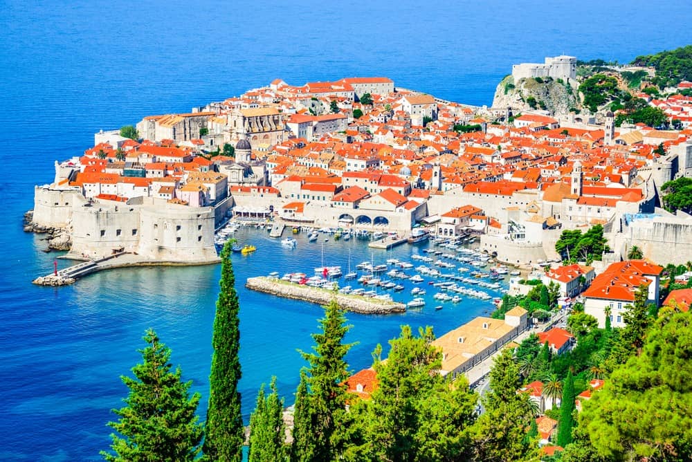
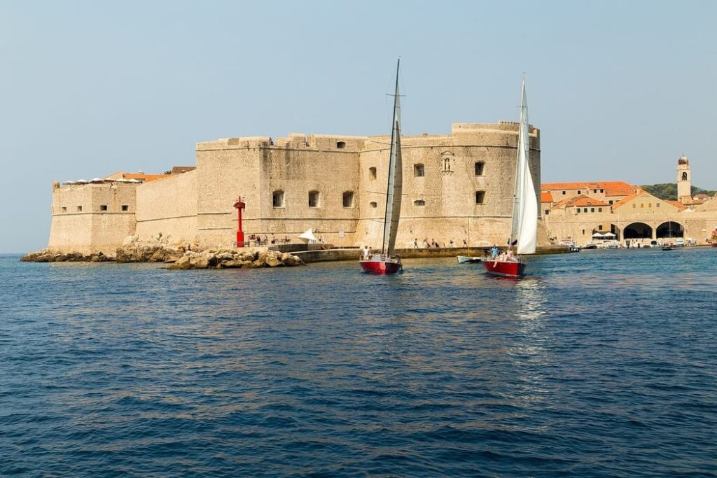
And, the last stop (21NM) of your sailing voyage is, of course, Dubrovnik. The medieval walled city of Dubrovnik is Croatia’s most well-known tourist destination. And, it has been a UNESCO World Heritage site since 1979. It’s totally worth visiting and exploring Dubrovnik’s Old Town. Gruz is a city and a commercial port on Croatia’s Adriatic coast, towards the SE end of the country’s long coastline. On the south side of the inlet, two miles NNE of the Old City, up the long river inlet of Rijeka Dubrovacka, is the ACI-operated Marina Dubrovnik. Dubrovnik is appealing in every season due to its uniqueness. It has incredibly beautiful surroundings, maintained cultural and architectural history, and excellent ecological standards. The Dubrovnik Summer Festival, which has been held annually since 1950, is the centerpiece of the city’s dynamic cultural and artistic calendar.
Best Sailing Routes in Croatia – The Bottom Line
We’ve come to the end of this non-exhaustive list of the best sailing routes in Croatia. As you see, these three main routes combine many islands and destinations in order for you to explore the most out of them. But, keep in mind that the Nautical Miles, as well as the duration of your voyage, will be determined by your preferences and schedule. When sailing in the Kvarner Gulf, the Kornati, and Zadar Archipelago, and generally in the Adriatic sea, it is advisable to always check at the map and nautical charts. Believe me, it is quite easy to make detours or even lose your route for a bit. This is because there are so many scattered islands, islets, reefs, and inlets that make it sometimes difficult to follow a direct route.
I hope that with this article as your guide you will plan your itinerary and choose the best sailing route in the Adriatic Archipelago!