Best Time to Sail Across the Pacific
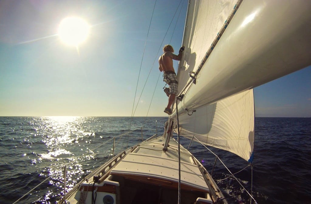
Crossing the Pacific Ocean is a dream for many, an amazing experience for some, and a lifetime voyage for the few ones. The Pacific Ocean offers different sailing conditions and unique experiences in comparison with other sailing destinations. Downwind sailing, a lot of cruising, unpredictable weather patterns, etc. But, even though the voyage is challenging, it ends up being more than just rewarding. From the green and rocky terrain of the Marquesas, with its massive waterfalls, to the coral atolls and azure lagoons of the Tuamotus, to Tahiti and Bora Bora, Vanuatu’s volcanic eruptions and lava cauldrons, and the breaching whales of the Coral Sea… And, there’s much more than that!
The Pacific Ocean is by far the most diverse when it comes to cruising. The landscapes, nature, and culture vary by location, and natural phenomena are always abundant. So, When Should you Sail Across the Pacific? In this article, I will give you information about the Pacific’s weather patterns as well as when is the best time to cross it. Keep reading!
Information about the Winds and Cyclones at the Pacific
The Pacific’s wind and pressure systems are very similar to the planetary system. Meaning that air pressure patterns and subsequent wind patterns occur in the Earth’s atmosphere as a result of its rotation (Coriolis force) and inclination of its axis toward the Sun. The Pacific’s enormous open sea influences wind and pressure patterns. And, the climatic conditions in the southern and eastern Pacific, where the trade winds and westerlies are very consistent, are the most uniform on the planet.
However, conditions in the North Pacific are not that consistent. This is because of the significant climatic changes between the eastern and western parts of the same latitude. The Pacific trade winds originate in subtropical high-pressure zones that are most apparent over the northeast and southeast Pacific between latitudes. They also constitute the eastern and equatorial sections of the air circulation system. The intertropical airflow is formed by easterly winds. These blow between the two subtropical zones, and are stronger in the eastern Pacific. The doldrums are an area of calms or light changeable breezes in the equatorial region. This is where the trade winds of the Northern and Southern hemispheres converge. The Pacific trade winds have an average speed of roughly 15 miles per hour (24 kilometers per hour). In the trade-wind belts, the weather is usually pleasant, with little cloud cover.
Within the westerly wind belts, cold easterly winds from polar regions collide with warm westerly winds from middle latitudes. This results in the formation of middle-latitude moving depressions. The westerlies in the Southern Hemisphere are consistent and forceful, earning them the name “brave west winds.”
Within about 10 degrees of the equator, the Inter-Tropical Convergence Zone (ITCZ), not to be confused with the SPCZ further southwest, is an area of frequent thunderstorms and squalls of varying amplitude. It requires careful boat preparation, time, and excellent weather resources to cross it safely.
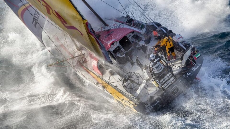
Despite the fact that the trade-wind belts’ climatic conditions are typically predictable and homogeneous, storms of considerable ferocity do occur there. Extremely strong winds spiral inward toward a center of extremely low air pressure in such storms. Typhoons are the name given to these storms, which are tropical cyclones in general. The Pacific doesn’t get the same furious storms or freezing spray as the North Atlantic, and it also doesn’t get the same severe frequency of tropical storms as the South Atlantic. The Pacific Ocean, on the other hand, has its fair share of harsh weather. Typhoons are the most powerful of all Pacific storms. They only occur in the Indian and Western Pacific oceans.
>>Also Read: Can a Sailboat Survive a Hurricane?
Pacific Monsoons, Temperature, and Tides
The planetary system is replaced by a seasonal climate regime in the western Pacific. This is the monsoon regime that is linked to the heating of Asia’s landmass in the summer and its extreme cooling in the winter. In the summer, the heating of air masses over tropical Asia initiates a low-pressure system that forms the focal point of both hemispheres’ trade winds. Because of the massive influx of marine air into the Asian low-pressure zone, the doldrums do not exist in the western Pacific throughout northern summer. Seasonal changes in pressure and wind circulation cause a noticeable seasonal contrast between continental and marine impacts in the western Pacific, from the Sea of Japan southward. The first is linked with drought and cold, while the second is associated with moisture and heat.
The main element that stratifies the seas is temperature; the deepest parts’ bottom waters are extremely cold, with temperatures just above freezing. Ocean temperatures in the North Pacific are generally greater than those in the South Pacific. This is because of the Northern Hemisphere’s larger land-to-sea ratio and the influence of Antarctica and the Southern Ocean on ocean temperature. Despite being in the Northern Hemisphere, the thermal equator in the Pacific is closer to the geographical equator than in the Atlantic and Indian oceans. The surface and deep zones of the Pacific have a significant temperature and salinity differential.
Unlike the tides of the Atlantic, the tides of the Pacific have a lot of diurnal and mixed tides. Only one high water and one low water occur each tidal day in the diurnal type of tidal oscillation. Large discrepancies in successive high (or low) water heights characterize mixed tides, which have both diurnal and semidiurnal cycles. This type of tide can be found all along the Pacific coast. The natural period of oscillation of the sea in particular parts of the South Pacific enhances the solar tidal oscillation. The tide in Tahiti, for example, follows the Sun rather than the Moon. There’s high water occurring around midnight and noon every day and low water occurring around 6 AM and 6 PM.
Best Time to Sail the North Pacific
The Pacific High, which stands on the rhumb line between San Francisco and Hawaii in July, is a high-pressure system. It goes south in the winter and gets less focused, and north in the summer and becomes more stable. In theory, at least. Before July, the Pacific High (high-pressure system) is frequently not well established. And, what is left of it is often located further south. As a result, this will make the voyage lengthier and more arduous. In this context, “difficult” refers to the light and contrary winds. Keep in mind that the Pacific High can be fairly diffuse and spread out in practice. The southeast corner of the high is usually associated with a ridge, and the winds there can be extremely light.
You can power through it if you’re not racing and have plenty of fuel. Otherwise, you’ll have to use light-air sails and drift gently. Something eventually changes, and you notice some wind. The solution is to sail south first, then turn west to reach Hawaii. The key is to not sail any further than is absolutely required. It’s critical to understand how to obtain current weather information and how to evaluate it.
Many things will be determined by your departure point. If you leave San Diego, you’ll be near to the bottom of the high. And, this is where you need to be for the crossing. You can also depart from the west coast at the end of April. This is when the weather from Anchorage to Vancouver is suitable for sailing.
During the winter and spring, you can expect to see a lot of low-pressure systems off the coast, which will bring strong southerly winds and huge seas. So, you have to be watchful for them. In the summer and fall, a powerful inland low-pressure system frequently forms a “squash zone” near offshore. This zone brings strong winds and seas from the northeast. This is normally a problem only north of Santa Barbara, and if you’re sailing south, it’s usually not a problem.
In general, the months of December to February are extremely cold for sailing in the North Pacific. But, March or April are the best months to sail. Like this, you will be in the best time so as to depart for the South Pacific in May when the southern cruising season begins. For instance, if you leave from Mexico to Hawaii, you can leave between March and May. Lastly, the ideal month to return to the Pacific Northwest is June.
Passing the Winter in Hawaii
You can winter over in Hawaii so as to avoid the southern storm season. If you’re leaving from the Marquesas, it’s a 2,000-mile journey northwest to Hawaii, which is mostly beam or broad reach. If you leave in late September/early October the passage will be great. At this time of the year, the winds are around 12-15 knots and there will be light seas for the entire trip, as well as a simple ITCZ crossing. Because of the wind angle advantage, the more east you can get for your departure north, the easier the trip will be. Timing and accurate weather information are vital for any lengthy journey. It also helps to have someone keep an eye on the ITCZ for you.
>>Also Read: Best Time to Sail to Hawaii
Best Time to Sail the Pacific Northwest
Sailing the Pacific Ocean near the United States and Canada’s Pacific Northwest is safe most of the year, but especially so in the summer. The weather in this area is generally mild, and convective storms are infrequent.
June and July are the ideal months to sail if you’re starting your journey from Portland, Seattle, or Vancouver, B.C. The area’s sailing season is long, lasting from March until the end of October. The main issue in the Pacific Northwest is that it is simply too cold to sail during the winter months.
Bear in mind that the further north you travel, the colder it gets. Winter temperatures in Seattle can range from moderate to extreme cold. It can be as cold as -5 degrees in Vancouver, which is far too cold for most people to sail in. This region’s water temperatures are cooler than the South Pacific, although not quite as frigid as it gets. In the Pacific Northwest, the greatest time to sail is during the summer, when pleasant temperatures and mild weather are most prevalent. During this season, Pacific ocean temperatures range from 60 to 65 degrees Fahrenheit, which is a pleasant temperature.
You should stay within 8 degrees of the equator or anywhere north of it in order to avoid the southern storm season. In addition, you can haul out at a cyclone-protected boatyard or anchor to a strong mooring in a sheltered anchorage. Like this, you will delay your course farther west. Hawaii, the Kiribati Islands, the Gilbert Islands, the Marshall Islands, Micronesia, New Zealand, the Solomon Islands, and Papua New Guinea are among the cyclone season cruising locations in the Pacific. There are several nice sites to haul out in French Polynesia, including Apataki in the Tuamotus and Tahiti and Raiatea in the Societies. Fiji and Tonga have powerful storm moorings in well-protected hurricane holes further west.
What to be Aware of When Sailing from French Polynesia to Australia
The distances between stops are substantially shorter from French Polynesia to Australia, and there are numerous things to see and do. There are island groups on both sides of the equator, so you may travel north and south to avoid the storm and typhoon seasons. Moving north and south within roughly 20 degrees of the equator is quite straightforward. This is because the trade winds normally flow from the northeast north of the equator and from the southeast south of the equator. Only when you want to return to the east are things more difficult, but not impossible.
If you choose to go west via the Federated States of Micronesia, just south of 10° N, to Palau you have to do so when the typhoon season in the northwest Pacific is over. You can spend the northern summer and most of the next winter in Palau. You can then travel southeast to New Guinea, the Solomon Islands, and the relative safety of the equator in March, thanks to the Northwest Monsoon.
When to Sail to Micronesia
Keep in mind that Micronesia is more dangerous than Polynesia in terms of sailing and weather phenomena. Tropical cyclones pose a significant danger. They are found in several places of Micronesia, however, they are rarely seen outside of season. In addition, typhoons constitute a significant threat in Micronesia, albeit they are less common than in other parts of the world. Micronesia is hot and humid all year, with highs of more than 90 degrees Fahrenheit. Between seasons, precipitation varies more than temperature, with some regions receiving as much as 11 inches in January and as little as 4 inches in August. The typhoon season in Micronesia extends from November to April. If at all possible, you should avoid sailing at this time or plan ahead of time using satellite weather data.
>>Also Read: Best Time to Cross the Atlantic by Sailboat
Best Time to Sail the South Pacific
Passage planning is essential, as is securing a favorable weather window for sailing. Because of its repetitive, windless weather, the ITCZ (intertropical convergence zone), also known as the doldrums, must be avoided. Light winds, squalls, and thunderstorms are common in the ITCZ, which is located near the equator and where the northeast and southeast trade winds converge.
You must choose the optimum path to the South Pacific trade winds, taking into account the Humboldt Current, which pushes north from Ecuador. Also, the Galapagos Islands which straddle the route and force either a north-bound or south-bound route around them. Probably your passage will coincide with the equinox, resulting in an unusual mirror ITCZ south of Galapagos. This will force you to choose the northerly course. You will experience a consistent 15 to 20 knots of real wind speed from the southeast until the time you hit the trade winds, which will probably last all the way to the Marquesas Islands.
The austral summer, which lasts from November to April, is a hotter, more humid wet season marked by torrential rainstorms interspersed with bright sunshine. The Solomon Islands, Papua New Guinea, Samoa, and Tahiti will be experiencing their peak rain season in October. Fiji and Tonga will be experiencing the height of their wet season in November. Therefore it’s best to avoid these months. It’s also crucial to remember that the tropical storm season occurs throughout the rainy season. It can last anywhere from November to the end of March, depending on the time of year you’re traveling.
Note that the dry season in the South Pacific runs from May to October. And, the wet season is from November to April. Also, the cyclone season is active from November to April. Lastly, the cyclone area is south of 10° S; west of 140° W.
What to be Aware of When Sailing from the Galapagos to the Marquesas
Bear in mind that the rhumb line is often not the quickest path to get to the desired location. In other words, favorable winds mean speed, and going the extra mile to find them is typically well worth it. By first traveling south-southwest down to 3 to 4 degrees south latitude, one should reach the upper limits of the southeast trade winds, albeit irregular at this point, when traveling from the Galápagos to the Marquesas. However, as you move west-southwest near 6 degrees south latitude and 100 degrees west longitude, their strength and consistency will be improved.
Because the trades will still have a southerly component, you should start experiencing your greatest noon-to-noon runs as you correct course toward your chosen port of entry in the Marquesas. This puts you on a broad reach, which is a sailing technique that most boats thrive at. The more west you go, the more easterly the trade winds become until you’re sprinting dead downwind. This is a little slower, with more pronounced rolling.
How Much Time do you Need to Cross the Pacific?
Firstly, it depends on the route you choose, your starting point, and of course, the months you will choose to set sail. Sailing across the Pacific may be a great cruising experience if you time it right and avoid the hurricane season. The world’s largest ocean is home to an abundance of natural beauty, unusual species, and culturally significant locations.
Keep in mind that the voyage can take around 10 weeks if the winds are favorable. For example, the distance between Panama and Australia is 8000NM. But, the weather, winds, and the number of stops you will make will determine the time you will need for this route. Note that the route you select will decide how long it takes you to get there, and the time of year will also play a role, as will any decision to stop and explore the islands along the way.
The cyclone season in the Pacific Ocean will determine when you can set sail. If Panama is your starting point, you have a window from February to June. In general, as the year progresses, the trade winds become more dependable and consistent. Leaving early in the season, on the other hand, provides you plenty of time to complete your travel without the added stress of cyclone season. Despite the fact that the formal window opens in February, depending on the cyclone projections, you might leave as early as late January. The chances of a major storm are substantially lower at that time of year than they are in the middle of the season.
>>Also Read: Is it Dangerous to Sail Across the Atlantic?
Best Time to Cross the Pacific with a Sailboat – The Bottom Line
As you may understand, the Pacific Ocean has different weather patterns according to the time of the year you choose to cross it. So, you have to plan your itinerary in order to avoid the storms and take advantage of the good weather for as long as possible. When deciding when to start a long cruise, the main goal is to avoid storms in typhoon-prone areas. Typhoons can strike at any time of year, although the months of May to October are the most common.
Storm seasons determine the best time to travel across the Pacific. Storms are a result of warm water and air, hence summer is storm season in both hemispheres. Warm water, and so storms, can drift further east during El Niño years. November to May is cyclone season in the southwest Pacific, which includes most of French Polynesia.
The hurricane season runs from June to November along the Central American coast. Typhoon season runs from June to November in the western North Pacific, but typhoons can strike at any time. Only roughly 8 degrees on either side of the equator is considered a relatively secure zone.
During the summer, you can safely travel along the western coasts of North and South America, then cross the eastern edge of Polynesia to Hawaii in October. Because the weather is warm and strong storms are uncommon, the Hawaiian Islands are normally safe during this season. You can freely travel Micronesia and Melanesia after the winter wet season. During the dry months of the South Pacific, temperatures regularly approach 86 degrees and seldom fall below 72. Sailing to New Zealand, Australia, and the numerous island chains in the most convectively dynamic portions of the Pacific Ocean is ideal from November to March.