Sailing Guide For the Bahamas: What You Need to Know
The Bahamas are located 50 miles away from Florida’s East Coast, and very close to other major areas of the US. So, sailing to the Bahamas is possible even with a small sailboat. So, what you need to be aware of is when and how to sail to the Bahamas. In this region, there are usually gentle trade winds of around 15 knots. In other words, the Bahamas are an easy sailing destination, and thus ideal for beginner sailors and families. But, of course, it’s an appropriate sailing destination for anyone that eagers to discover this natural gem. Keep in mind that the high season, and also the best time to visit the Bahamas, is from September to May, with temperatures averaging 21-24°C. So, let’s see some more details about the Bahamas below; both for beginners and experienced sailors. Keep reading!
Gems in the Lucayan Archipelago – the Bahamas
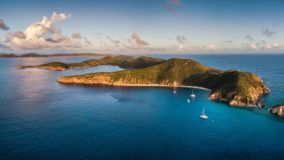
We’re not still quite aware of how many islands and islets form the Lucayan Archipelago. According to some estimates, there are about 2,400 of them spread across a breathtaking 590-mile-long archipelago, with the nearest location being only one day’s sail from Florida for several vessels. Keep in mind that there are only about 50 villages or towns on these islands. The majority are small islets with rocky shorelines and pink-tinged white beaches. Each hides curly tail lizards, hermit crabs, and birds among the mangrove, casuarina, palmetto, sea grape, and coconut palms. The Bahamas’ most stunning feature, however, is the ocean’s wonderland, with its warm turquoise waters that cover much of the shallow Bahama Banks.
Despite the fact that the Bahamas’ western waters are just a little over 40 miles from Florida at their closest point, the culture, dialect, and speed are all very Caribbean. The mighty Gulf Stream, a warm and strong river in the ocean with a current flowing from south to north, makes up the 40-plus mile. It can be an amazing voyage if you cross it in the right conditions. However, crossing it in inclement weather, such as heavy northerly winds, can be risky and inconvenient. Choose your weather carefully; aim for flat calm or gentle southerlies, and avoid going when a cold front or storm is approaching.
On a clear day, you can see fish, sharks, and rays moving swiftly away from your hull’s shadow when cruising along the Bahama banks. Another stunning image; grass and fan corals move along with the current below you. Moreover, you’ll see plenty of exotic fish, lobster, and moray eel hiding among the brain coral. The banks are divided by dramatic troughs leading from the shallows out to the oceans. A live example is the Tongue of the Ocean and the Northwest Providence Channel, whose shifting watercolors from light turquoise to deep blue leave even the most experienced travelers speechless.
The islands of the Bahamas are situated mostly along the edges of the banks. Bear in mind that on some of the outer islands, food and mail arrive by boat. Also, telephone and electricity in homes are recent developments. The Bahamas are mostly known for the cities of Nassau or Freeport. However, most sailors want to visit islands that are located a bit farther off, such as Long Island, Royal Island, Crooked Island, Highborne Cay, Green Turtle, Eleuthera, Mayaguana, Ragged Island, and the Jumentos. Or, anchor and explore islands and islets that have no names at all, except names that locals have given to them.
Climate and Winds in the Bahamas
The climate in the Bahamas is mild all year-round and is an important feature of the area. The average temperature ranges from 21 degrees Celsius in the winter to a low of 27 degrees Celsius in the summer. It rarely drops below 16 degrees Celsius or rises above 32 degrees Celsius. The average annual rainfall is 44 inches, with the majority of it falling during the summer months. A humid atmosphere is created by the prevailing winds, which come from the northeast in the winter and the southeast in the summer. Tropical cyclones, also known as hurricanes, are common from June to November and have the potential to cause significant damage.
The subtropical monsoon climate of the Bahamas maintains a pleasant temperature throughout the year. The highest temperatures are usually seen in the early mornings and late afternoons when the sun is less strong. From December to February, the average temperature is between 21 and 24 degrees Celsius, while the rest of the year is colder, with temperatures ranging from 27 to 29 degrees Celsius. Keep in mind that the best weather for sailing is with winds between 5 and 20 knots, except during the hurricane season.
The Bahamas, on the other hand, are unlikely to be struck by a hurricane. This is due to the fact that they mostly head to the United States’ mainland. If you’re sailing to the Bahamas during hurricane season, make sure you take every precaution you can. You should always keep an eye on the weather, navigate correctly, and have a seaworthy vessel. And, finally, let’s note that the peak season is from April to December. Therefore, this makes the Bahamas beaches, areas, and ports more crowded.
What About Your Boat?
The type and size of your boat play a crucial role in any sailing voyage you’re planning. A seaworthy vessel that can withstand rough weather conditions is always recommended for long passages. So, it’s important to pick the correct weather for you to navigate as well as organize carefully your voyage beforehand. And, also your ability to moor or anchor when the weather isn’t good or is expected to change for the worse. The boat, on the other hand, must be big enough and well-built to navigate the open ocean when the wind and sea get worse. Your boat must also be big and heavy enough to safely transport the equipment and supplies you’ll need for your voyage.
Boats designed for offshore fishing trips can be great for sailing in the Bahamas. And, if you plan to layover at resort marinas, center consoles designed for blue-water fishing are common in the Bahamas. However, most people prefer cabin accommodations that allow them to anchor out when they want. This can be a highlight of every Bahamas cruise in a well-protected harbor.
Speed is also an important factor for your voyage. To get from a good east Florida departure point to a safe harbor in the western Bahamas, a boat sailing at six knots is going to need half of the day cruising. This is due to the influence of the strong northerly Gulf Stream current on a slow-speed displacement hull, not just because of the speed. This boat may need several days of good weather to reach the Abacos, and even longer to reach the northern Exumas.
However, a boat traveling on plane at around 25 knots is able to get to the western islands of the Bahamas in a couple of hours and perhaps Marsh Harbor or Nassau within a day. While a faster boat helps you to take advantage of shorter weather windows, be sure to leave enough time. If you need a weather window for more than a few days, it’s likely to disappoint you near the end.
Anchoring & Safety in the Bahamas
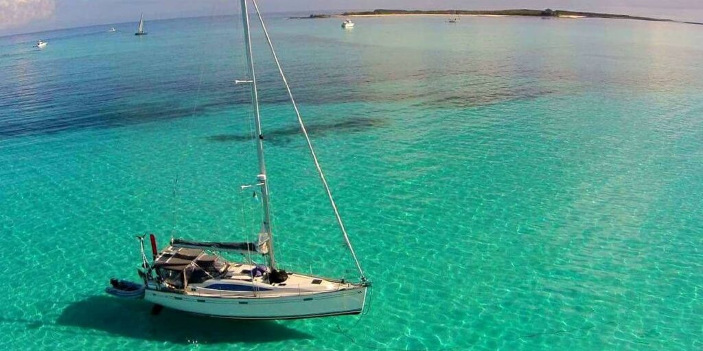
Even if you don’t want to anchor overnight, good anchoring equipment is important. If you break down, you will be forced to anchor for several hours while you try to repair the problem or wait for assistance. The bottom will most likely be sand, either hard or soft. And, keep in mind that there are also a lot of places with a lot of thick grass and a hard rock or coral bottom that don’t hold up well. As you already know, there’s no anchor that will work well in all types of bottoms. So, it’s advisable to be equipped with two anchors so as to have a better chance of holding depending on the bottom.
Many sailors recommend carrying CQR and Fortress anchors. If weight is a concern, the Fortress has incredible holding power and can be used for a variety of bottoms. It’s also lightweight and can be easily disassembled for storage and reassembled for usage. Furthermore, an all-chain rode is advantageous because the chain will not be cut by rocks or other debris on the bottom, and its weight will aid anchor holding. However, this chain is too heavy for some small sailboats.
A good option would be a combination of chain and nylon rode. The more chain between the anchor and the nylon, the better, as long as it isn’t too heavy. Also, a windlass can be very useful depending on the size and windage of your boat, as well as your physical fitness. Note that corals are never a good place to anchor. Moreover, allow space for other vessels, for the shore, and reefs to swing around in a 360-degree circle. Windage, bottom configuration, eddies, and currents all affect how a boat swings.
Nowadays, navigation is easier with GPS chart plotters. But, never rely entirely on technology as it’s more than likely that it will let you down. This is because sand shoals change annually, and rocky bars and reefs may not be perfectly charted in the first place. A GPS is as good as the chart you’re relying on. Meaning that strong currents in inlets can unexpectedly take you onto rocks even as you watch the icon on the screen. You can even get into trouble if your GPS equipment or device isn’t working properly. The term “crowdsourcing” doesn’t always work in these situations; you never know how experienced “the crowd” is or how accurate their conclusions are. You might even end up on a reef if you’re a little off…
So, it’s advisable to carry some guidebooks and paper charts when you go sailing in the Bahamas. Otherwise, extrapolated GPS waypoints from mixed data may not be that accurate. When you’re navigating an inlet that’s just a few hundred feet deep, with swells, rocks, and reefs all around you, being accurate is a must. And, also, remember that navigational aids in the Bahamas are uncommon and often neglected.
The Bahamas, unlike the more forgiving waters of the Chesapeake Bay, are fraught with rocks, reefs, and brown bars that can easily sink a boat, and there is no daily presence of the US Coast Guard. Even though there are some excellent salvage aids, but the seas they must navigate are enormous. Inconveniences and, in some cases, lengthy repair times are the result of a lack of infrastructure. Keep in mind that there are few to no safe marinas or decent anchorages for storm protection. So, take care and navigate cautiously in the Bahamas, the place of stunning wilderness. Reliable charts will help you to do so!
Some of the Best Routes in the Bahamas
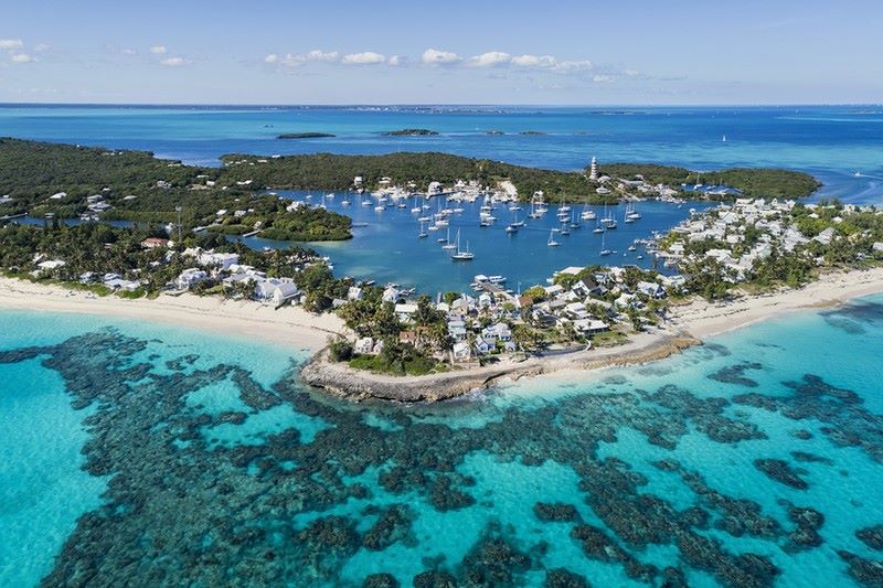
The most common and best routes from the United States to the Bahamas include Bimini, the Abacos, and the northern Exumas. Across the Gulf Stream from Miami and Fort Lauderdale is the Bimini Chain there’s a collection of small cays (pronounced “keys”). The islands of North and South Bimini, as well as Cat Cay, are settled there. The Bimini Road’s mysterious stone slabs lie underneath nearby waters; a mysterious legend of Atlantis. Bimini has a village, many marinas, restaurants, and now a resort/casino and a Hilton Hotel, which is popular with the sportfishing fleet.
The Bimini islands, including Cat and Gun cays, are one of the most common layovers for sailors. Cat Cay is an easy port of entry and Gun Cay is a beautiful place to explore for a few nights before heading across the Great Bahama Bank. And, after you cross the banks, you have numerous choices to continue your voyage. For instance, you can anchor and explore the Berry Islands, stay in Nassau and do some shopping in this crowded area, continue to the magnificent Eleuthera, head south for the Exumas and the far Out Islands beyond, among others. Keep in mind that this voyage is based on a sailboat that can travel between 15 and 25 knots in moderately calm waters.
Bimini 50NM: Sailing to Bimini, Lucaya, Cat Cay, or any other island in the western Bahamas will take you about 50 miles. These destinations will give you a taste of what to expect deep into the Bahamas, but they will also give you a feel for crossing the Gulf Stream. To the north of Cat Cay, you may anchor your sailboat behind Gun Cay.
The Abacos 190NM: The Abacos, which are located next to Grand Bahama Island, are home to Hopetown, Marsh Harbor, and Man of War. This place considered one of the most crowded ones in the Bahamas because it provides more civilization than most other regions, such as museums, shopping, and restaurants.
A great route to sail to the Abacos is from Palm Beach. You will sail 60 miles across the Gulf Stream before a layover at the Old Bahama Bay Marina at West End. The next 100 miles of your voyage should take you to Green Turtle Cay. After that, you can sail 20 miles to the Abacos’ center, Marsh Harbor, the Bahamas’ Boating Capital. Sailing 15 miles south will take you to Little Harbor, where you’ll find a variety of marinas and anchorages.
Northern Exumas 220NM: This cruise will take you to one of the Bahamas’ most beautiful out-island destinations. You can set sail from Fort Lauderdale or Miami and sail 50 miles to Bimini, where you can make your first stop. After that, you can travel 80 miles south to Chub Cay. Then, continue to Nassau (the Bahamas’ capital), which is nearly 40 miles across the Tongue of the Ocean. You can then sail to the Northern Exumas, but be careful because there are many reefs at Nassau Harbor’s southern end. The Highbourne Cay Marina, Sea Park at Warderick Wells, and the Exumas Land Marina are all located in Northern Exumas.
Islands that Shouldn’t be Missed
Berry Islands: These stunning islands are for those that look for tranquility and exploration of nature. There, most of the cays are undeveloped and uninhabited. The only centers are located at Chub Cay, which is where the new Chub Cay Resort and Marina are situated.
Eleuthera: Eleuthera is a lovely and somewhat off-the-beaten-path destination for cruisers. In most areas, the island is less than a half-mile wide and almost 100 miles long. Hatchet Bay has a fantastic anchorage with virtually all-around security, Governor’s Harbour is a lovely village, and Rock Sound is a place where all amenities can be found.
Andros: Andros is an archipelago in the Bahamas and the largest of all. It isn’t a common layover for sailors and that’s why it still is a natural paradise. Fresh Creek, as well as Morgan’s Bluff, are the most frequented areas by sailors. If you’re keen on scuba diving, Andros has a barrier reef that extends more than 140 miles along the island’s east coast. The reef has a depth of 6,000 ft and forms part of the western edge of the trench; the Tongue of the Ocean.
Useful Tips for all Sailors Sailing to the Bahamas
- Never anchor in a reef or anywhere where your anchor rode might get tangled in the coral.
- The best bottoms have deep and soft white sand. You can clearly see them from the bow of your boat. But, keep in mind to differentiate them from bottoms of white rock, marl, or shallow white sand over rock.
- In addition, when you anchor in the grass and the wind increases, this will result in dragging and therefore damage the marine habitat.
- “Squeeze plays” between large areas of high and low pressure will result in strong winds blowing for several days, mostly from the east.
- Strong southwesterly winds also precede winter cold fronts, which arrive as a strong, precipitous westerly, then north-westerly. Then the winds shift to a nor’easter and continue to blow for days.
- In hurricanes and tropical lows, the Bahamas have little protection. With so little land to buffer the impact of wind and sea, even enclosed harbors can be vulnerable. Also, in comparison to US waters, expect no assistance.
- Bear in mind that in many areas like the Exumas, potable water is scarce. Also, its cost is at 50 cents per gallon or more at the dock. Consider finding marinas with reverse-osmosis facilities. But, in other areas, water is more plentiful, for example in the Hub of The Abacos.
- There are marinas that are temporarily closed or have limited access because of the weak economy. Search beforehand for these details before setting sail.
- Fueling in the Bahamas can be tricky and it’s possible to run out of gas at any moment. So, maintaining a strong reserve in your tanks is important. Ensure that your boat is equipped with a high-quality particle/water fuel filter, such as those manufactured by Racor. You can use a Racor RFF15 C (15-gpm funnel) to pre-filter diesel, which separates water and particulate.
- Even though a popular destination, most of the Bahamas are still natural and secluded areas. Many places lack navigational aids or if they have some they might not be working at all. So, it’s crucial to learn how to read the water. Keep an eye on the guidebooks and stay alert. From your boat, you can see the bottom, which is often more than 25 feet deep.
- Note that in case something breaks, it might be difficult to repair or replace it, especially in remote areas. So, always carry spares for essential components and systems. For instance, a water pump for your fresh-water system, a starter and alternator, spare engine oil, belts, gasket material, and temporary repair items like Rescue Tape are some of the things might need.
- The Bahamas charge an entrance fee of $150 for vessels under 35 feet and $300 for vessels over 35 feet. The fee includes a fishing license and departure tax for four individuals. You’ll be asked to declare your purchases as well as your overall itinerary. It’s possible that your boat will be boarded and examined. Lastly, note that laws and policies can change from time to time.
Bahamas Sailing Guide – The Bottom Line
The Bahamas form an archipelago of 30, 000sq.km of turquoise clear blue waters. The islands are undoubtedly among the most preferred sailing destinations in the world. However, there are still many secluded corners and the overall image is a natural wilderness. Bear in mind that you can sail to the Bahamas year-round, but the best time to sail is between December and April. Some sailors say that the best season is from late March to early June. This is because the northerlies have passed and the hurricane season hasn’t begun. Don’t forget to always plan ahead, carry charts, and a GPS navigation system that will aid your course. Check the weather and the bottoms as well. Lastly, as facilities are limited to some islands, consider carrying spare parts, water, and maps. Wish you all a pleasant voyage to the Bahamas!